Use slope-angle maps while planning a ski tour, a splitboard outing, or a mountain hike. Read the on-map legend, adjust the shading, and include slope angle in your offline download before leaving cell service.
Available with Outmap Pro on iPhone and Android. Offline use requires downloading the area with the slope-angle layer included.
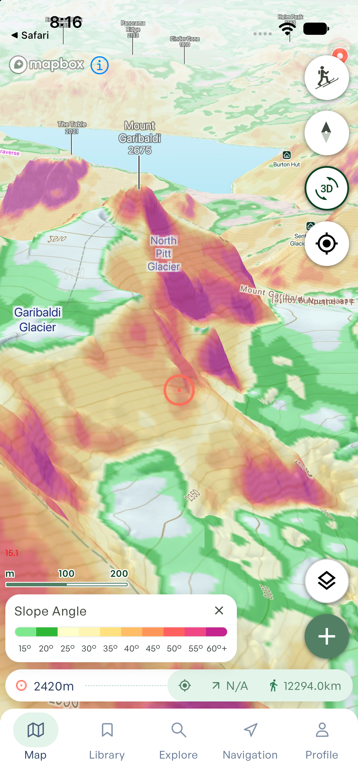
Look beyond the route line
A route line shows where you intend to go. Slope-angle shading helps you examine the ground around it.
When planning a ski tour, compare the approach, the climb, and the intended descent. Look for changes in steepness along the route and inspect the surrounding slopes as well. Use those differences to identify sections that deserve a closer look before you choose an objective.
Switch to slope aspect when you want to examine which direction a slope faces. Angle and aspect answer different questions, and Outmap provides a separate terrain layer for each.
Read the colors using the legend
The slope-angle legend connects the map’s colors to angles in degrees. Match a shaded area to the legend to interpret its steepness, then compare it with nearby terrain.
Adjust the layer’s opacity to keep the map underneath readable. The colors describe terrain steepness; they are not avalanche danger ratings or a signal that a slope is safe.
How to turn on slope angle on your phone
- Open Outmap and find the mountain area you want to inspect.
- Tap the layers button on the map.
- Open the Terrain tab and select Slope angle. A Pro subscription is required.
- Zoom in until the shading and slope-angle legend appear.
- Use the Opacity slider in the Terrain panel to adjust the shading, then return to the map to compare slopes.
See the slope-angle help guide.
Download slope angle before heading offline
Include slope angle when you prepare an offline map. In the app, tap +, choose the map-download option, and select your area, map quality, and terrain layers. Make sure Slope angle is included.
Wait for the download to finish before leaving your connection. As a pre-trip check, open the downloaded area without an internet connection and confirm that the map and slope-angle shading you need are visible.
Read about offline terrain layers or follow the map-download guide.
What a slope-angle map can—and cannot—tell you
Slope-angle shading is calculated from elevation data. It represents mapped terrain, rather than a measurement of the snow surface beneath your feet. Small terrain features and changes in the snow surface may not be represented.
Use it as one planning input. It does not show current snow stability, replace an avalanche forecast, or establish that a route is safe. Read the relevant forecast and combine map planning with field observations and appropriate training.
Questions about Outmap’s slope-angle maps
Is the slope-angle layer free?
The slope-angle layer requires Outmap Pro. You can download the app for free, then review the available subscription options in the app.
Can I use slope-angle maps on iPhone and Android?
Yes. Outmap’s mobile app supports iPhone and Android, with slope angle available through Pro in the Terrain tab.
Does slope angle work without cell service?
Yes, when you have downloaded the area with the slope-angle layer included. Viewing an area online is not a substitute for preparing an offline download.
Why can’t I see slope-angle shading?
Check that Slope angle is selected under Terrain and that you have Pro access. Zoom in to view the layer, and check the opacity setting. If you are offline, confirm that your download includes slope angle for the area you are viewing.
How accurate is the slope-angle map?
Its detail depends on the underlying elevation data. Treat the shading as an estimate of mapped terrain steepness. Zooming in does not guarantee that small rolls, cliffs, or snow features are represented accurately.
Is slope angle the same as slope aspect?
No. Slope angle describes steepness. Slope aspect describes the direction a slope faces, such as north or south. Select the separate Slope aspect layer to examine orientation.
Is this an avalanche forecast?
No. Slope-angle shading describes terrain. An avalanche forecast describes avalanche conditions for a particular region and time period. Consult the relevant forecast alongside your terrain planning.
Can I use it for hiking or mountaineering?
Yes. Slope-angle shading can help you compare steepness around mountain routes beyond the ski season. It does not tell you whether a trail exists, a passage is accessible, or a route is suitable for your experience.
Explore the terrain for your next trip
Find your destination in Outmap, open Terrain, and turn on Slope angle with Pro. Compare the slopes around your route before you head out.
Download for iPhone · Download for Android
Explore terrain layers, 3D maps, and more Outmap features · Plan on the web