
Backroad status
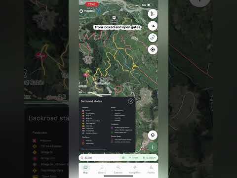
Backroad status colors the forestry and backcountry roads on your map by their condition, so you can check the road to the trailhead before you leave home. The layer covers BC and Alberta.
Turning it on
- Open the layers menu Tap the layers button on the map, go to the Overlays tab and tap Backroad status. The description underneath reads "Road access updates for BC and Alberta." To turn it off, tap it again.
- The legend A Backroad status legend appears at the bottom left of the map. Tap it to open it, and tap the arrow to tuck it away again.
Reading the map
- Roads Every road is colored by its condition: green for good, yellow for degraded, red for heavily degraded, a black dotted line for impassable and a grey dashed line for unknown. Best for: spotting which sections of a road to trailhead are rough before you go.
- Features Icons mark the things that can stop you: an impasse, a high-clearance 4x4 bypass, a bridge in, a bridge out, a bridge in an unknown state, a foot bridge only, and open, locked and potential gates.
- Fire zones Active fires and fire perimeters are marked on the map.
- Cut blocks Pending logging activities, active or recently logged areas and retired logging areas.
- Closure zones Areas that are closed to motor vehicles, and areas that are open to them.
Recent bulletins
- Backroad Status website At the bottom of the legend there's a link to backroadstatus.com, which is where the road data comes from. Open it to read the recent bulletins, with updates from people who have recently done the road, like a note about a section of road. Best for: checking the latest word on a road, a bridge or a gate before you drive it.
Important: road conditions change quickly, and a bulletin might be days old by the time you read it. Check the date on any report, and be ready to turn around if the road isn't what you expected. Always rely on your own training and judgment.