
Downloading Offline Maps
Downloading an area
- Starting an area download On the map, tap the plus button in the bottom right and choose Download map. You can also tap the layers button, go to the Offline tab and tap Download map at the bottom.
- Position the download box A green box appears on the map, so drag and zoom until it covers the area you want to save. Everything inside the box gets downloaded.
- The measurements The length of the box's sides is shown along its edges, for example 3.8 km. The box is a square, so both sides match. Use it to see how big the area is as you move and zoom.
- Choose what to save Pick Topo only, Satellite or Satellite HD. Each option shows an estimated download size. With satellite you can also choose the imagery, Maxar, Mapbox or Winter Beta, and you can tick the terrain layers to save too: Slope angle, Slope aspect, Avalanche risk, Flat areas and Elevation bands. Saved layers keep working with no signal. Then tap Download map at the bottom of the panel, enter a region name you'll recognise later, like the name of the area or objective, and tap Download. To back out, tap Cancel.
- Best for A mountain range, the surroundings of a hut, or a trip without a fixed route. If you only want to follow a route, use a route download instead, which follows the shape of the route.
Downloading a route
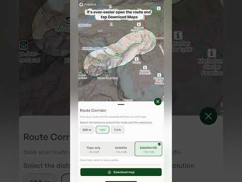
- Download maps Open a saved route, swipe along the row of buttons at the bottom of the route panel and tap Download maps. A panel called Route Corridor opens, saying "Save your route and the selected distance on each side." Instead of a square, Outmap saves a strip of map that follows the shape of your route.
- Choose the distance Choose how far around the route to save: 500 m, 1 km or 2 km. The outline on the map widens as you change it, so you can see how much terrain each option covers. A narrow corridor takes less space, and a wider one gives you more terrain around the route for side trips and exits. Best for: long routes, where a square would waste space on places you'll never go.
- Sizes change with the width The size estimates for Topo only, Satellite and Satellite HD go up as the corridor gets wider, and they depend on how long the route is. For example, a 2.7 km hike came to roughly 90.0 MB for Topo only, 93.0 MB for Satellite and 97.7 MB for Satellite HD with 500 m on each side, and Satellite HD rose to about 101.4 MB at 1 km.
- Choose what to save Then pick Topo only, Satellite or Satellite HD, and any terrain layers you want, the same choices you get for an area. Give it a name and tap Download.
Managing your offline maps
- The Offline tab Open the layers menu and go to the Offline tab. Before you've saved anything it says "No maps downloaded yet". Once you have, the heading shows how many maps you've saved, like Offline Maps (2), and each one is listed with a thumbnail, its name and its size. You can also check when each one was last updated and how much space it takes.
- Download before you leave You need a connection to download, so save your maps before you head out of signal, ideally on wifi. Check that the download has finished in the Offline tab before you go.
- Storage There's no fixed limit on how much offline map data you can save. The limit is the free space on your phone, and Outmap keeps some in reserve so your phone doesn't fill up completely.
- The three dots menu Tap the three dots next to a map for more options. Rename map lets you change its name, Delete map removes it from your phone, Validate offline map lets you check a saved map, and Resume download picks up a download that was interrupted, so you don't have to start again.
Tip: save your maps before you leave, then check the map still loads with your phone in airplane mode. Offline maps hold the map and the terrain layers you chose, but live information like weather and avalanche forecasts needs a connection to update, so check those before you lose signal.